On Monday, Feb. 16, Chicagoland was the warmest it has been on the same day in 125 years, according to the National Weather Service.
The temperature reached 65 degrees, surpassing the 1921 record of 58 degrees.
Weather experts attribute the rise in temperature to El Nino, “A warming of temperatures in the equatorial Pacific Ocean,” said Professor of Atmospheric Sciences Jeffrey Frame for the University of Illinois.
Although warmer than average, this winter was also colder than average in early January.
On Friday, Jan. 23, the temperature dropped 32 below zero, prompting ECC and neighboring school districts to close their doors.
What led to the closure was “the nature of what was going on with all the neighboring schools” and “specifically how cold it was,” said Emergency Management Administrator Stephen Stassen for ECC.
“This winter has been thus far colder and snowier than average across a lot of the Midwest into the Great Lakes and northeast,” Frame said. “Now, we’re looking at another thaw coming in here, mid-February.”
That first thaw started during late December and continued throughout the beginning and end of January.
“We had the thaw around Christmas, the Grinch thaw, that continued into the first half or so of January, and then the last half of January,” Frame said.
The thaw also followed into February, leading to temperatures last week skyrocketing over 60 degrees.
This Monday, however, the temperature dropped to 31 degrees, with the rest of the week experiencing similar temperatures, according to The National Weather Service.
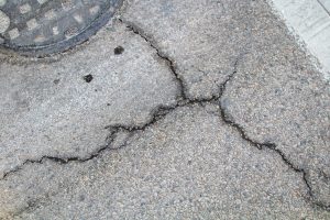
Below-freezing weather created cracks in concrete through the freeze-thaw cycle, as water seeped into the concrete and then expanded. (Quinn Konneman)
Although there are dramatic shifts in the weather during this month, most of February will be considered to be warmer than normal.
“Certainly, it looks like we’re turning much warmer here to wind up February,” Frame said.
Temperature drops will become less frequent and eventually come to an end, with the chance of rain becoming higher.
“The periods of very below-average temperatures that we’ve endured will be coming to an end. It also looks like we’ll at least be getting some more bouts of precipitation,” Frame said.
While the Midwest area will be getting rain, it is still relatively dry due to the lack of snow this winter.
“This calendar year so far, 2026, has also been quite dry,” Frame said.
That caused the soil to not regain moisture from the melting snow, making it a possible issue for crop production.
“Those crops need moisture out of the ground, and so what we need to do is start recharging that soil moisture,” Frame said.
Following the winter, El Nino will still commence during the summer as well as the fall, and with a possibility of taking effect next winter as well.
“Our prediction models that we use to forecast seasonal climate do pretty strongly indicate that an El Nino will begin setting in this summer and then probably continuing on through the fall and maybe next winter,” Frame said.
El Nino isn’t the only weather pattern that occurs; there is also La Nina, which is a, “Periodic cooling of the water in that[Equatorial part of the Pacific,” Frame said.
Both of these weather phenomena are a “natural oscillation[fluctuation],” Frame said. “They don’t “Have anything to do with climate change.”
While they don’t have anything to do with climate change, El Nino and La Nina are the main components for temperature fluctuations and will still be ongoing in the future.
![[FILE PHOTO] The November print edition gets passed around during an Observer pitch meeting.](https://elginobserver.com/wp-content/uploads/2025/11/newspaper-1200x800.jpg)
![[FILE PHOTO] Student life vans, reserved for trips and other uses, are parked outside Building F, on May 6, 2026. Student life only have one wheelchair accessible van out of all the vans available, making trips that need to accommodate a disabled student challenging.](https://elginobserver.com/wp-content/uploads/2026/05/reversednegatives-06514-1200x800.jpg)
![[File photo] First semester Industrial Engineer Student Josiah Matthews discusses how he enjoys the challenges that come with complex math problems with staff writer Viviana Avila. Photo Taken in the D building Hallway](https://elginobserver.com/wp-content/uploads/2025/09/Josiah-Matthews-1-Math-1200x800.jpg)